


Waterloo Voting District, Laurens County, South Carolina
About
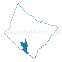
Outline

Summary
| Unique Area Identifier | 666237 |
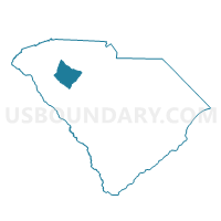
| Name | Waterloo Voting District |
| County | Laurens County |
| State | South Carolina |
| Area (square miles) | 27.77 |
| Land Area (square miles) | 25.68 |
| Water Area (square miles) | 2.10 |
| % of Land Area | 92.45 |
| % of Water Area | 7.55 |
| Latitude of the Internal Point | 34.32362770 |
| Longtitude of the Internal Point | -82.06608400 |
Maps

Graphs
Select a template below for downloading or customizing gragh for Waterloo Voting District, Laurens County, South Carolina


Neighbors
Neighoring Voting District (by Name) Neighboring Voting District on the Map
- Coronaca Voting District, Greenwood County, SC
- Cross Hill Voting District, Laurens County, SC
- Ekom Voting District, Laurens County, SC
- Lower Lake Voting District, Greenwood County, SC
- Mountville Voting District, Laurens County, SC
- Mt. Olive Voting District, Laurens County, SC
- Stonewood Voting District, Greenwood County, SC
Top 10 Neighboring County Subdivision (by Population) Neighboring County Subdivision on the Map
- Greenwood CCD, Greenwood County, SC (49,961)
- Ninety Six CCD, Greenwood County, SC (7,383)
- Princeton CCD, Laurens County, SC (6,514)
- Cross Hill CCD, Laurens County, SC (5,445)
Top 10 Neighboring Place (by Population) Neighboring Place on the Map
Top 10 Neighboring Unified School District (by Population) Neighboring Unified School District on the Map
- Greenwood School District 50, SC (58,872)
- Laurens School District 55, SC (37,250)
- Laurens School District 56, SC (20,726)
- Greenwood School District 52, SC (7,366)
Top 10 Neighboring State Legislative District Lower Chamber (by Population) Neighboring State Legislative District Lower Chamber on the Map
Top 10 Neighboring State Legislative District Upper Chamber (by Population) Neighboring State Legislative District Upper Chamber on the Map
Top 10 Neighboring 111th Congressional District (by Population) Neighboring 111th Congressional District on the Map
Top 10 Neighboring Census Tract (by Population) Neighboring Census Tract on the Map
- Census Tract 9706, Greenwood County, SC (7,708)
- Census Tract 9702.01, Greenwood County, SC (4,085)
- Census Tract 9202.02, Laurens County, SC (3,284)
- Census Tract 9210.01, Laurens County, SC (2,778)
- Census Tract 9210.02, Laurens County, SC (2,667)
- Census Tract 9707.01, Greenwood County, SC (1,999)
Top 10 Neighboring 5-Digit ZIP Code Tabulation Area (by Population) Neighboring 5-Digit ZIP Code Tabulation Area on the Map
- 29646, SC (28,159)
- 29649, SC (26,235)
- 29360, SC (20,977)
- 29384, SC (3,945)
- 29332, SC (2,435)
- 29370, SC (1,045)